


(PRLEAP.COM) Topo.ly, an online mapping company, has launched international territory boundaries to its Plus users. For years, it has many requests from its thousands of users from all over the world about adding more international boundaries. Among these users are based or having business in Canada. Recently, Topo.ly announced new addition to Canadian territory:
Canada ProvincesCanada Forward Sortation Areas
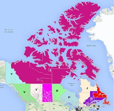
Canada Provinces
Topo.ly users can now make an in-depth analysis of their data using Canada provinces. It offers the complete 10 provinces and 3 territories in Canada. The list include:
Alberta British Columbia Manitoba Nanabut New Brunswick Newfoundland and Labrador Northwest Territories Nova Scotia Ontario Prince Edward Island Quebec Saskatchewan Yukon Canada Forward Sortation AreasFSAs (Forward Sortation Areas) represent the first 3 digits of Canada's 6-digit postal code. They are usually used by government offices, non-government organizations and businesses to conduct studies and surveys. Sorting out the postal codes give them different perspectives as they acquire important information needed for their cases. Some of the most prominent reasons of using this postal code segregation are:
Marketing analysis Census Health registries Real Estate The new Canada territory boundaries are available to use by Plus version subscribers for data analysis and heat mapping.| < Prev | Next > |
|---|


